


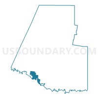
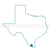
Voting District 0029, Hidalgo County, Texas
About
Outline

Summary
| Unique Area Identifier | 674724 |
| Name | Voting District 0029 |
| County | Hidalgo County |
| State | Texas |
| Area (square miles) | 15.76 |
| Land Area (square miles) | 15.34 |
| Water Area (square miles) | 0.42 |
| % of Land Area | 97.32 |
| % of Water Area | 2.68 |
| Latitude of the Internal Point | 26.17858970 |
| Longtitude of the Internal Point | -98.36377340 |
Maps

Graphs
Select a template below for downloading or customizing gragh for Voting District 0029, Hidalgo County, Texas


Neighbors
Neighoring Voting District (by Name) Neighboring Voting District on the Map
- Voting District 0012, Hidalgo County, TX
- Voting District 0050, Hidalgo County, TX
- Voting District 0063, Hidalgo County, TX
- Voting District 0094, Hidalgo County, TX
- Voting District 0100, Hidalgo County, TX
- Voting District 0128, Hidalgo County, TX
Top 10 Neighboring County Subdivision (by Population) Neighboring County Subdivision on the Map
- McAllen-Pharr CCD, Hidalgo County, TX (267,929)
- Mission CCD, Hidalgo County, TX (158,485)
- Sullivan City CCD, Hidalgo County, TX (33,306)
Top 10 Neighboring Place (by Population) Neighboring Place on the Map
- McAllen city, TX (129,877)
- Mission city, TX (77,058)
- Palmview South CDP, TX (5,575)
- Palmview city, TX (5,460)
- Perezville CDP, TX (5,376)
- Abram CDP, TX (2,067)
Top 10 Neighboring Unified School District (by Population) Neighboring Unified School District on the Map
- La Joya Independent School District, TX (93,891)
- Mission Consolidated Independent School District, TX (61,468)
- Sharyland Independent School District, TX (39,935)
- Hidalgo Independent School District, TX (8,019)
Top 10 Neighboring State Legislative District Lower Chamber (by Population) Neighboring State Legislative District Lower Chamber on the Map
Top 10 Neighboring State Legislative District Upper Chamber (by Population) Neighboring State Legislative District Upper Chamber on the Map
Top 10 Neighboring 111th Congressional District (by Population) Neighboring 111th Congressional District on the Map
Top 10 Neighboring Census Tract (by Population) Neighboring Census Tract on the Map
- Census Tract 204.02, Hidalgo County, TX (8,200)
- Census Tract 242.05, Hidalgo County, TX (7,845)
- Census Tract 202.01, Hidalgo County, TX (7,364)
- Census Tract 213.05, Hidalgo County, TX (7,279)
- Census Tract 202.02, Hidalgo County, TX (7,190)
- Census Tract 201.02, Hidalgo County, TX (7,150)
- Census Tract 201.01, Hidalgo County, TX (6,321)
- Census Tract 242.04, Hidalgo County, TX (4,518)